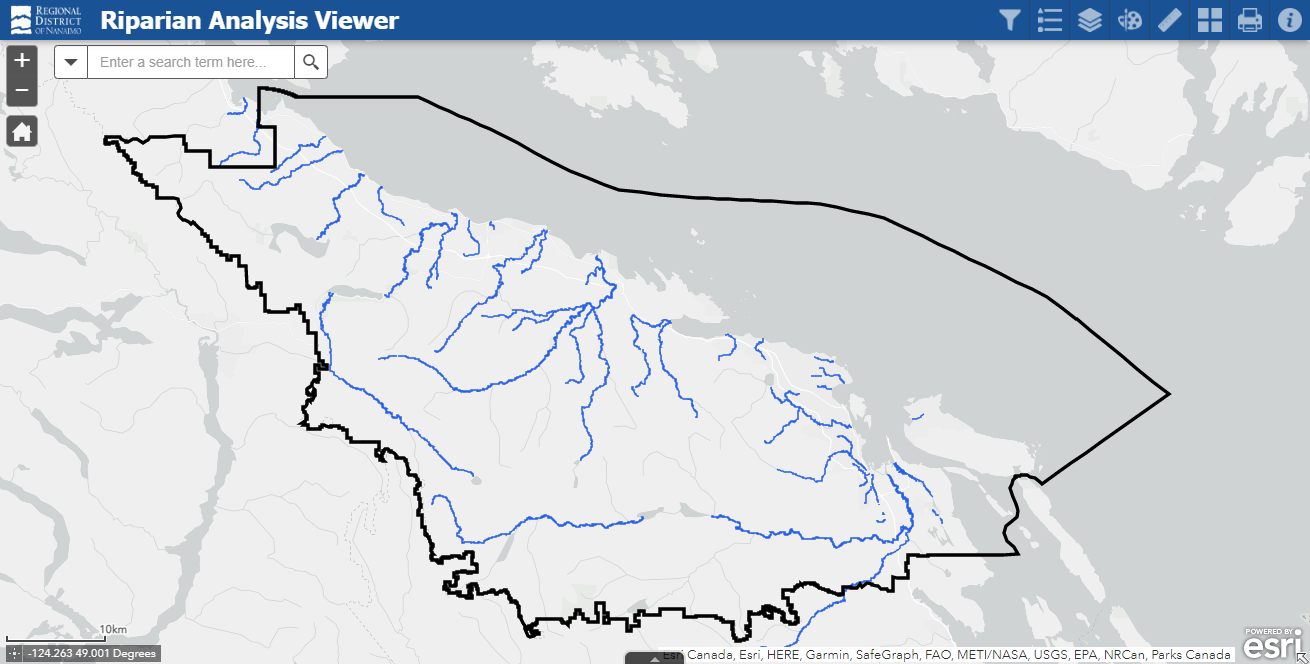
Riparian Analysis Map
Our region is experiencing increased air and water temperatures, prolonged drought periods, and increased frequency of high intensity rainfall events as a result of climate change. To buffer these extremes, intact and functional riparian areas are essential for promoting cooler air and water temperatures in heatwaves, offering water filtration and flood protection during high rainfall events, and providing overall enhanced biodiversity, ecosystem services and climate resilience.
To understand the state of riparian cover across the region’s major watercourses and guide future restoration and enhancement efforts, the RDN’s Drinking Water & Watershed Protection (DWWP) engaged with McTavish Resource & Management Ltd to determine current functional riparian cover levels across the region’s watersheds, using aerial imagery, remote sensing data, and existing water quality data collected through the RDN’s Community Watershed Monitoring Network.
The Regional Riparian Spatial Analysis for Restoration Prioritization project assessed the riparian condition of 47 waterways across the RDN based on a prioritization scheme that considers eight parameters associated with riparian health, including:
- Disturbance,
- Zones of concern,
- Vegetation cover,
- Terrestrial habitat cover and continuity,
- Vegetation complexity and structural diversity,
- Soil parent material and texture,
- Water quality, and
- Climate
The goal of this assessment is to identify priority areas for restoration of riparian vegetative buffers and enhance climate resilience and water protection in the region.
An outcome of this project included the development of an interactive mapping tool that allows decision-makers, water stewards, and community members to interact with the results of the riparian spatial analysis and support the prioritization of restoration and enhancement efforts. Users of the Riparian Analysis Map Viewer can interact with a visual depiction of the results of the analysis, identify and prioritize areas for restorative efforts, as well as, build tailored maps with the use of a suite of informative layers, identifiers, and mark-ups to aid in the scoping and planning of restoration projects.
Click on the map below to enter the Riparian Analysis Map Viewer:
The vision of the RDN's Drinking Water & Watershed Protection program is for healthy, safe, and resilient water resources in the region. Learn more at dwwp.ca
Click on the image below to enter the Riparian Analysis Map Viewer:
The Riparian Spatial Analysis for Restoration Prioritization investigates functional riparian cover across 47 waterways within the Regional District of Nanaimo. View the full report here:
Your feedback is welcome! Don't hesitate to contact us with your comments, questions, and concerns by emailing waterstewardship@rdn.bc.ca